Tu sei qui

Indirizzo: 435 E (East) 77TH ST APT 10A (From 10A To 10H), NEW YORK, NY 10075-2322, USA

Che cos'è 10075-2322? 10075-2322 è un codice di 5 Plus 4 numero di avviamento postale del 435 E (East) 77TH ST APT 10A (From 10A To 10H), NEW YORK, NY, USA. Di seguito è riportato informazioni dettagliate.

10075-2322 Informazioni di base

img_Postal
  • CAP 5 Plus 4:

    10075-2322
  • CAP 5:

    10075
  • Plus 4?
    4-digits that are used to identify a geographic segment within the 5-digit delivery area, such as a city block or a group of apartments or an individual high-volume receiver of mail, or any other unit that could use an extra identifier to aid in efficient mail sorting and delivery. This code is the low end of the range of +4 Codes that pertain to this ZIP Code. ZIP+4 Codes associated with nondelivery areas are composed of valid ZIP sector numbers and "ND" for the ZIP segment number, for example 12345-12ND. Non-deliverable areas are areas to which the USPS does not deliver mail, such as vacant lots and land that borders railroad tracks. Mailers should not match an address identified as a nondelivery area. If you absolutely must have numeric characters in the Plus4Code column, you may treat "ND" values as "00" (zero zero).
    :
    2322
  • Paese:

    U.S. - Stati Uniti
  • Stato:

    NY - New York
  • Contea:

    CountyFIPS: 36061 - New York County
  • Città:

    NEW YORK
  • Via Predirezionale:

    E (East)
  • Strada?
    The official name of a street as assigned by a local governing authority. The Street Name column contains only the street name and does not include directionals (EAST, WEST, etc.) or suffixes (ST, DR, BLVD, etc.). This element may also contain literals, such as PO BOX, GENERAL DELIVERY, USS, PSC, or UNIT. Numeric street names that have numeric components that are four characters (or less) in length at are justified such that the low-order digit of the number is positioned in the fourth position of the street name column. This shift is made so that the numeric street names appear in numeric sequence.
    :
    77TH ST
  • Via Suffisso?
    The street suffix: For Example: ST = Street RD = Road DR = Drive LN = Lane
    :
    ST (Strada)
  • Tipo di Record?
    An alphabetic value that identifies the type of data in the record. Record type codes include the following: G = General delivery H = Highrise F = Firm S = Street P = PO box R = Rural route/highway contract
    :
    H: Highrise

Indirizzo

img_region

10075-2322 corrisponde ai seguenti indirizzi.

Elenco indirizziStato
435 E (East) 77TH ST BSMT SUPT, NEW YORK, NY 10075-2322, USAvalido
435 E (East) 77TH ST APT 11A (From 11A To 11D), NEW YORK, NY 10075-2322, USAvalido
435 E (East) 77TH ST APT 8G (From 8G To 8H), NEW YORK, NY 10075-2322, USAvalido
435 E (East) 77TH ST APT 9A, NEW YORK, NY 10075-2322, USAvalido
435 E (East) 77TH ST APT 12A (From 12A To 12D), NEW YORK, NY 10075-2322, USAvalido
435 E (East) 77TH ST APT 9C (From 9C To 9H), NEW YORK, NY 10075-2322, USAvalido
435 E (East) 77TH ST APT 10A (From 10A To 10H), NEW YORK, NY 10075-2322, USAvalido

Indirizzo Esempio

img_region
L'indirizzo è composto dalle seguenti righe:
435 E (East) 77TH ST
NEW YORK NY 10075-2322
UNITED STATES OF AMERICA
oppure È possibile controllare l'esempio della busta di seguito per ulteriori informazioni.

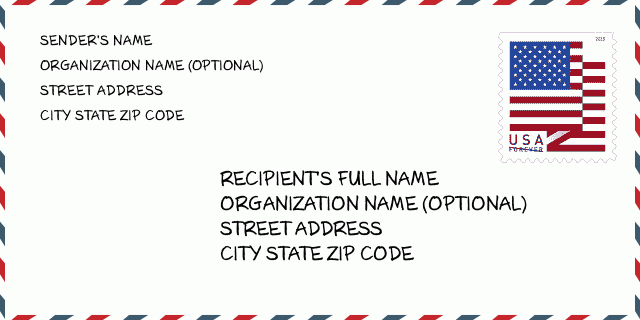
10075-2322 Esempio di busta

img_envelope
  • Questo è un esempio di busta statunitense. Inserisci le informazioni del mittente in alto a sinistra e le informazioni del destinatario in basso a destra. Le informazioni necessarie sono il nome completo del mittente/destinatario, l'indirizzo, la città, lo stato e il codice postale. Le informazioni sull'indirizzo del destinatario sono state fornite come riferimento. In generale, se non sei sicuro del codice postale completo di 9 cifre, puoi inserire solo il codice postale di 5 cifre per evitare la perdita del pacco.

    ZIP Code: 10075-2322

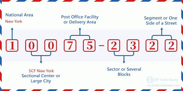
10075-2322 Significato di base

img_envelope
  • Cosa significa ogni cifra del CAP 10075-2322? Il CAP+4 è composto da due parti, le prime cinque cifre possono essere localizzate all'ufficio postale e le ultime quattro cifre possono identificare un segmento geografico all'interno dell'area di consegna a cinque cifre. Le 6-7 cifre indicano un settore o più blocchi e le 8-9 cifre indicano un segmento o un lato di una strada.

    ZIP Code: 10075-2322

Online Mappa

Online Mappa

Questa è la online mappa dell'indirizzo 435 E (East) 77TH ST, NEW YORK. Possibile usare bottone a muovere e sfrecciare in/fuori. Le informazioni di mappa è solo per riferimento.

Indirizzo: 435 E (East) 77TH ST APT 10A (From 10A To 10H), NEW YORK, NY 10075-2322, USA

Commento

Commento

Aggiungi un commento