現在地

アドレス: 455 W (West) 34TH ST APT 7H (From 7H To 11H), NEW YORK, NY 10001-1544, USA

10001-1544とは? 10001-1544 455 W (West) 34TH ST APT 7H (From 7H To 11H), NEW YORK, NY, USA の5桁郵便番号に4桁をプラスした番号である。以下は詳細情報である。

10001-1544基本情報

img_Postal
  • 郵便番号5プラス4:

    10001-1544
  • 郵便番号5:

    10001
  • プラス4?
    4-digits that are used to identify a geographic segment within the 5-digit delivery area, such as a city block or a group of apartments or an individual high-volume receiver of mail, or any other unit that could use an extra identifier to aid in efficient mail sorting and delivery. This code is the low end of the range of +4 Codes that pertain to this ZIP Code. ZIP+4 Codes associated with nondelivery areas are composed of valid ZIP sector numbers and "ND" for the ZIP segment number, for example 12345-12ND. Non-deliverable areas are areas to which the USPS does not deliver mail, such as vacant lots and land that borders railroad tracks. Mailers should not match an address identified as a nondelivery area. If you absolutely must have numeric characters in the Plus4Code column, you may treat "ND" values as "00" (zero zero).
    :
    1544
  • 国:

    U.S. - 米国
  • 州:

    NY - ニューヨーク州
  • 郡:

    CountyFIPS: 36061 - New York County
  • 市:

    NEW YORK
  • ストリートプレ方向指示器:

    W (West)
  • ストリート?
    The official name of a street as assigned by a local governing authority. The Street Name column contains only the street name and does not include directionals (EAST, WEST, etc.) or suffixes (ST, DR, BLVD, etc.). This element may also contain literals, such as PO BOX, GENERAL DELIVERY, USS, PSC, or UNIT. Numeric street names that have numeric components that are four characters (or less) in length at are justified such that the low-order digit of the number is positioned in the fourth position of the street name column. This shift is made so that the numeric street names appear in numeric sequence.
    :
    34TH ST
  • ストリートサフィックス?
    The street suffix: For Example: ST = Street RD = Road DR = Drive LN = Lane
    :
    ST (ストリート)
  • レコード形式?
    An alphabetic value that identifies the type of data in the record. Record type codes include the following: G = General delivery H = Highrise F = Firm S = Street P = PO box R = Rural route/highway contract
    :
    H: 高層

アドレス

img_region

10001-1544 は以下のアドレスに対応します。

アドレス一覧状態
455 W (West) 34TH ST APT 11A (From 11A To 11G), NEW YORK, NY 10001-1544, USA有効
455 W (West) 34TH ST APT 10A (From 10A To 10G), NEW YORK, NY 10001-1544, USA有効
455 W (West) 34TH ST APT 12A, NEW YORK, NY 10001-1544, USA有効
455 W (West) 34TH ST APT 9A (From 9A To 9G), NEW YORK, NY 10001-1544, USA有効
455 W (West) 34TH ST APT 8A (From 8A To 8G), NEW YORK, NY 10001-1544, USA有効
455 W (West) 34TH ST APT 7H (From 7H To 11H), NEW YORK, NY 10001-1544, USA有効

アドレス例

img_region
アドレスは次の行で構成されています。
455 W (West) 34TH ST
NEW YORK NY 10001-1544
UNITED STATES OF AMERICA
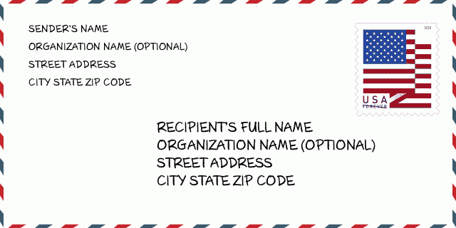
または詳細については、以下の封筒の例をご覧ください。

10001-1544封筒の例

img_envelope
  • これは米国の封筒の例です。左上に送信者の情報を入力し、右下に受信者の情報を入力します。必要な情報は、送信者/受信者の氏名、住所、都市、州、および郵便番号です。参照用に受信者のアドレス情報が提供されています。通常、完全な9桁の郵便番号がわからない場合は、パッケージの紛失を防ぐために5桁の郵便番号のみを入力できます。
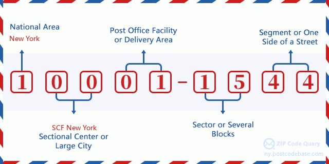
    ZIP Code: 10001-1544

10001-1544基本的な意味

img_envelope
  • 郵便番号10001-1544の各桁は何を表していますか?ZIP + 4コードは2つの部分で構成され、最初の5桁は郵便局に配置でき、最後の4桁は5桁の配達エリア内の地理的セグメントを識別できます。 6〜7桁はセクターまたは複数のブロックを示し、8〜9桁はセグメントまたは通りの片側を示します。

    ZIP Code: 10001-1544

オンライン地図

オンライン地図

これは住所455 W (West) 34TH ST, NEW YORKに対応するオンライン地図である。地図の中のボタンを利用して移動、拡大・縮小を実現できる。地図情報はただご参考にされて下さい。

アドレス: 455 W (West) 34TH ST APT 7H (From 7H To 11H), NEW YORK, NY 10001-1544, USA

コメント

コメント

コメントを追加